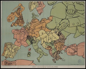
 During World War I, satirical maps of Europe became a hotly contested battle zone of competing propaganda. Still waiting for the Eurozone version of this.
Ever wonder why today’s camouflage is pixelated? Apparently, to avoid detection in today’s main source of surveillance: digital imagery. The Paris Review features Hanna Rose Shell’s new book on camouflage and the media of reconnaissance.
CUNY’s Center for Urban Research has made an impressive interactive map combining newly released 1940s census data with images, color-coded maps, and stats from New York City Market Analysis, a 250-page survey of the city published in 1943. The rent in my old neighborhood would have been less than $50 in 1940s New York.
A glimpse into the future of cyber-war: This week marks the third discovery of a super sophisticated state-sponsored malware. Flame, as the malware is known, was mostly targeted at Iran, leading most to suspect that Israel and/or the U.S. are behind the spyware. As if the so-called “rules of war” needed further muddling…
